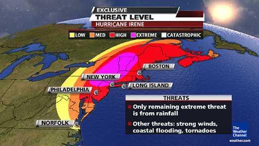
[UPDATE 8/28] Hurricane Irene has turned inland and The Weather Channel has updated their threat graphic showing reduced, but still high, risk for the Oyster River area.

[UPDATE] The New York Times has published an interactive tracking map for Hurricane Irene showing estimated path and wind speed over time.
Hurricane Irene is currently expected to travel up the Atlantic coast and hit seacoast New Hampshire late Sunday/early Monday. Threat levels are categorized as "Extreme" by The Weather Channel — the latest information can be found on their Hurricane Irene Status and Forecast page.

Oyster River residents should prepare for potentially high winds, rain, and extended power interruption. Please take care and look out for one another.
No comments:
Post a Comment